|
|
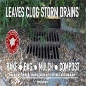
Stormwater ProgramPublic asked to report blocked drainsThe City's Stormwater Operations Crew routinely maintains the City's drains, culverts, and 103 tidal outfalls, as well as handles daily work orders and service requests. If you see a blocked storm drain please report it on the City's website or via email, and be sure to include pictures, whenever safely possible!
|
|
|
|
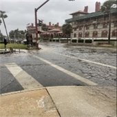
King TidesUpcoming Dates PredictedKing Tides are the highest predicted high tides of the year. NOAA defines King Tides as, "a King Tide is a popular, non-scientific term people often use to describe exceptionally high tides". King Tides often cause nuisance flooding in coastal and low-lying areas. More severe flooding can occur if the King Tide coincides with severe weather conditions (heavy rain, strong winds, big waves). September 16-22
October 16-21
November 13-19
December 12-18
January 11-15
January 29-31
To remain safe during a King Tide, avoid driving through standing water. If necessary to drive through standing water, proceed slowly and with caution to avoid creating a wake. Avoid parking and leaving vehicles in areas prone to flooding. For daily high tide information, please visit the NOAA Daily Tide Chart or the St. Augustine Marina WeatherSTEM.
|
|
|
|
|
|
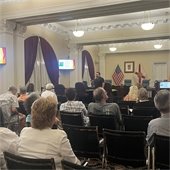
Back Bay Feasibility StudyWith the Army Corps of EngineersOn January 9, 2023 City officials signed an agreement with the Army Corps of Engineers to begin a Coastal Storm Risk Management (CSRM) Federal Feasibility Study. This study will investigate coastal storm impacts on the City and identify solutions to reduce damages that will benefit the community as future projects are designed to mitigate flooding. The City will utilize American Rescue Plan Act (ARPA) funds for its cost share match with the Army Corps of Engineers. Once complete, the study will allow the City to qualify for federal funding opportunities for future flood mitigation projects. Public Workshop Scheduled October 23, 2024A public workshop is scheduled to take place on Wednesday, October 23, 2024, at 6:00PM in The Alcazar Room at City Hall, located at 75 King St, St. Augustine, FL 32085. The public is invited to learn more and give opinions on the Initial Array of Alternatives that have derived from an in-depth analysis of potential impacts over 50 years into the future arising from a range of risk factors. Learn more at the city's website or submit public comment here.
|
|
|
|
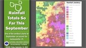
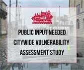
Public input sought for Citywide Vulnerability Assessment StudyPublic meeting Tuesday, September 17 The City of St. Augustine is seeking public input for the Citywide Vulnerability Assessment study and a meeting is scheduled for Tuesday, September 17 at 5:00pm in The Alcazar Room of City Hall, located at 75 King Street. A vulnerability assessment helps a community measure potential impacts from flooding and sea level rise as well as identify structures, infrastructure, people, and natural resources that may be affected. This assessment is focused specifically on impacts to community assets. You can learn more here.
|
|
|
|
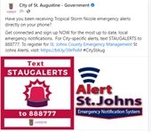
2024 Hurricane SeasonEmergency Alert Notification SystemDo you know how to get emergency alerts from the City sent directly to your phone? StAugAlerts is an emergency notification tool that works in conjunction with Alert St. Johns. This system will only be used in the event of imminent danger to life or property. Sign up to receive emergency alerts from the City directly to your phone by texting StAugAlerts to 888777. Receive alerts about emergencies by signing up for the St. Johns County Emergency Notification System, Alert St. Johns Call the St. Johns County Emergency Operations Center Phone Number at (904) 824-5550 or visit www.SJCEmergencyManagement.com anytime for information about sandbags, bridge and road closures, evacuation routes and shelter openings during a storm event. Other Tips:- Know if you live in an evacuation Zone by entering your address in St. Johns County's 'Know your Zone' website
- Make preparations BEFORE the storm. If you need Flood Mitigation Assistance, check out these resources on the City's website.
- Learn how to understand forecasts. For the most up-to-date, local weather info, follow FSWNCityStAug on Facebook and Twitter, and bookmark this web page.
- Find the most local, current, and accurate information by following the City, Fire Department, Police Department, and Municipal Marina on social media.
|
|
|
|
Sandbag TipsKeep your sandbags until the end of storm season!When a hurricane is brewing, the City will often supply residents with the opportunity to collect sandbags before the storm. Here’s what you need to know: - Sandbags are good for more than one use
- They should be kept until the end of storm season.
- You can dispose of the sandbags by cutting the bag open and dropping the sand either in your yard or in a neighboring wooded area.
- Only once the sand is emptied should you place the bag in the garbage.
- The City’s Solid Waste office does NOT collect sandbags at any time.
Call the City’s Solid Waste Department at 904-825-1049 or contact St. Johns County Solid Waste office at 904-827-6980 for potential disposal assistance. The City’s Solid Waste office does NOT collect sandbags at any time.
|
|
|
|
2024 Flood Mitigation Assistance ProgramApplications Due October 1, 2024The FEMA Flood Mitigation Assistance (FMA) program is a resource provided to the City meant to reduce or eliminate the risk of repetitive flood damage to buildings and structures insured under the National Flood Insurance Program (NFIP). To qualify, residents must have NFIP backed insurance no later than August 31, 2024. The FMA Program is a nationally competitive annual FEMA grant program. Applications will be due in October 1, 2024. Prioritization is given to those structures listed as Severe Repetitive Loss and Repetitive Loss which is determined by FEMA. More workshops will be scheduled in the fall. To learn more, please email us here or visit the city's website.
|
|
|
|
Back Bay Study Project Delivery Team MeetingsMonthly virtual meetings are open to the publicMonthly Project Delivery Team Progress Meetings for the Back Bay Feasibility Study are virtual and open to the public. All meetings are scheduled for 1:00PM-2:30PM. Click here to access the virtual meeting room. Phone Number: 844-800-2712
Access Code: 199 927 9909 Upcoming dates for 2024 are as follows:
|
|
|
|
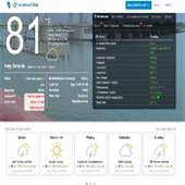
Live Weather DisplayAt the St. Augustine Municipal MarinaThe weather can change in a moments notice, so the St. Augustine Municipal Marina has installed live weather displays located in the breezeway of the marina to keep visitors and guest aware of pending weather. The information displayed includes: - Weather data updated in real time from a WeatherSTEM station on site.
- Temperature, humidity, heat index
- Wind speed, 10min wind gusts, wind direction, wind chill
- Real time closest lightning notification
- Weekly forecast
- Weather alerts
- Marine forecast
- Live radar
- Hurricane forecast
- Daily tide chart for “slack tide”
You can always stay connected with visiting the FSWN CityStAug Weather STEM website to check the weather downtown at anytime.
|
|
|
|
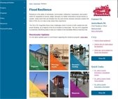
Resiliency ResourcesCheck out the City's website!The City has a number of resources on the City's website including links to daily tide charts, helpful links with flood hazard information and storm preparedness tips. We also offer the following: - Residential Site Visits
- Neighborhood Meetings
- Informational Presentations
- Maintenance Service Requests
Please contact us here for more information!
|
|
|
|
|
|